


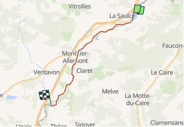
La Saulce à Ventavon

DaVinci
User

Length
14.6 km

Max alt
572 m

Uphill gradient
51 m
Km-Effort
15.4 km

Min alt
519 m

Downhill gradient
102 m
Boucle
No
Creation date :
2020-02-08 10:56:51.961
Updated on :
2020-02-08 10:57:32.039
2h25
Difficulty : Medium

FREE GPS app for hiking
 SityTrail
IGN / Geographical institutes
SityTrail Plus
The world is yours!
About
Trail Canoe - kayak of 14.6 km to be discovered at Provence-Alpes-Côte d'Azur, Hautes-Alpes, La Saulce. This trail is proposed by DaVinci.
Positioning
Country:
France
Region :
Provence-Alpes-Côte d'Azur
Department/Province :
Hautes-Alpes
Municipality :
La Saulce
Location:
Unknown
Start:(Dec)
Start:(UTM)
262811 ; 4922902 (32T) N.
Comments